Warburton
OS Grid ref:- SJ697896
 The historic village of Warburton is situated between the Rivers Bollin and Mersey and lies around 4 miles (6.44 km) from the market town of Altrincham.
 Referred to in the Domesday Book as Warburgtune, the suffix 'ton' denotes a settlement or farmstead in Anglo-Saxon, it has been suggested that Warburton was the site of the Anglo-Saxon burgh or defended settlement, known as Weard byrig, which was established in 915 by Aethelflaeda, Lady of the Mercia (died 918), the daughter of King Alfred the Great, when she fought Viking incurssions into the area, but it is now thought more likely that this site actually lay on the WalesCheshire border.
It seems more likely that the name derives from St.Werburgh, an Anglo-Saxon saint and patron saint of Chester, to whom the village church is dedicated. Werburgh (died circa 700 AD) was the daughter of Wulfhere, ruler of the Anglo-Saxon kingdom of Mercia and St. Ermenilda, daughter of King Eorcenberht of Kent, she was also a grand-daughter of Penda of Mercia. St. Werburgh was Abbess of Ely and was instrumental in convent reform across England. She died in 699 at Trentham, she was formerly buried at Hanbury in Staffordshire where her shrine remained for around 160 years. When the mortal remains of St Werburgh were removed to what is now Chester Cathedral, to protect them from Viking attacks, they were placed into a casket and in around 1340, were housed in an ornate carved shrine.
Warburton is mentioned in the Domesday Book of 1086, where the two manors of Warburton were recorded, the manors had joined together to form one settlement by the late twelfth century. Prior to the Battle of Hastings, the area was owned by the Saxon thegn Aelfward. In 1086 it is recorded as being the property of William, son of Nigel.
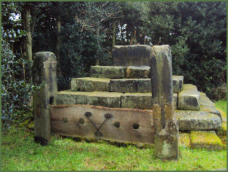
 The base of the ancient village cross still survives, situated on Townfield Lane, the cross itself is said to have been destroyed by zealous Puritans during the Civil War and is surrounded by a wall of stone flags. The adjacent village stocks (pictured above left) possibly date back to the seventeenth century, they were restored circa 1900 by Mr. Barff.
The school house, parish rooms and caretaker's house were designed by the famous Chester architect, John Douglas (18301911). The high-level cantilever toll bridge crossing the Manchester Ship Canal and was built in 1865 and is one of the few remaining pre-motorway toll bridges in the UK.
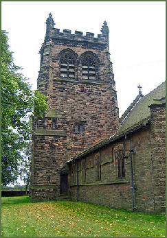
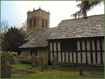
There are two churches of St Werburgh in Warburton, the older church, (pictured right) is situated to the west of the village and stands beside the Manchester Ship Canal, it possibly dates back to the mid thirteenth century, of the 29 timber framed churches that survive in England and Wales, St Werbugh’s is one of the oldest. The newer church was constructed from 1883 to 1885 and and stands to the southeast of the village.
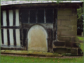
 The old St Werbergh's church is a combination of brick and sandstone, the original building was of wattle and daub with a thatched roof, the 1000-year history of the church is clearly reflected in it's buildings and fittings. The structure has some surviving wattle and daub infilling in the north wall and has a superb roof supported on rough timber beams. The structure was extensively altered and restored in 1645, when the south and west walls of the nave were rebuilt and the roof was lowered. The brick tower is early Georgian, as is the east end of the chancel. The church may occupy the site of an earlier Saxon chapel, although there is no record of such in the Domesday Book.
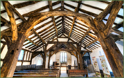 The chancel was altered and a pulpit, altar rails and communion table were installed in the late sixteenth century and in 1645 the south and west walls of the nave were rebuilt, a chapel and vestry with a stone foundation and timber framed wall were added to the south side of the chancel and a stone extension was added to the north side.
In 1857 the walls were painted with medieval designs and a minton tile floor was added to the chancel. The octagonal font is inscribed with the date 1603 and the words "William Drinkwater the Keeper".
There are also several twelfth century stone coffins in the church, which were probably used for priors of the abbey which once stood next to St Werburgh's. A sundial dating from 1765 stands in the churchyard. The lych gate was added in 1887. The ditch and bank surrounding the building probably dates to at least the fourteenth century. The church is no longer used, though is open to the public and is now in the care of the Churches Conservation Trust.
By 1880 the old church required major repairs, and accordingly, the new church of St. Werburgh was built. Designed by John Douglas, it contains a font cover dating from 1595 and an oak parish chest which was removed from the old church.
Warburton is also the site of a medieval priory, near the Church of St Werburgh, founded in 118790 by Adam de Dutton, it was a Premonstratensian priory/cell of Cockersand Abbey in circa 1200 and dissolved before 1271, the remains were said to have been destroyed by King Henry VIII in 1536, after the Catholic rising known as the Pilgrimage of Grace, no trace of the building has survived to the present day, but a field adjoining the old Rectory is known as Abbey Field.
Time Team at Warburton
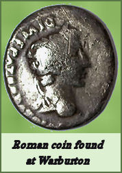 At the invitation of local historian and metal detector Jim Balme, the Time Team carried out excavations in the lands of Moss Brow Farm in Warburton in September 2006, to locate a previously unknown Roman settlement after hearing about an array of archaeological finds unearthed in a field.
James Balme has been investigating the area around Warburton for more than a decade and discovered a Roman silver snake bracelet lying on the surface of a farmer's field in 2006, he also unearthed a hoard of eight Roman silver Republican Denarius coins, dated between 252 BC and 2 BC and a collection of Roman metalwork. The bracelet was declared National Treasure and is now in Manchester Museum.
Alhough no evidence of a Roman fortlet was found by Time Team, the discovery of strip lynchets, a feature of ancient field systems, indicates that there was a Romano-British farm in Warburton.
External links
Nearby places of interest
Dunham Massey, situated three miles south west of Altrincham. The house dates from the Georgian period, and was built around a Tudor core, but underwent extensive restoration in the Edwardian era. The result is one of Britain's most sumptuous Edwardian interiors.
Walton Hall Gardens, situated to the south west of Warrington, was originally part of a much larger country estate, purchased in 1812 by the famous Greenall brewing family.