Ward's Stone
OS Grid ref:- SD492727
 Ward's Stone is the highest fell in the Forest of Bowland, in Lancashire, designated an Area of Outstanding Natural Beauty (AONB). The fell rises to a height of 561 metres (1,841 feet).
Ward's Stone forms part of a large wedge of moorland that protrudes from the main Bowland massif.
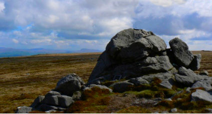
The plateau's flat summit has two trig points which stand almost a kilometre apart. The western trig point (at an altitude of 560 metres), sits near large rocks, one of which, known as the Ward's Stone, is so large it attracts boulderers and climbers. The eastern trig point at 561 metres, overlooks the eastern part of the Forest of Bowland, facing the summits of Wolfhole Crag, White Hill and Ingleborough.
On a clear day the view is from the western trig point is superb providing stunning panorams of the the Lake District fells, Morecambe Bay and even the distant mountains of Snowdonia.
The path from Grit Fell is an arduous one, a second path approaches Ward's Stone from Tarnbrook, where limited parking is available.