Anchor Church
O.S. Grid Ref:-SK3327
 Anchor Church Caves are situated in an outcrop, in a highly attractive setting between Foremark and the village of Ingleby, in the Peak District National Park.
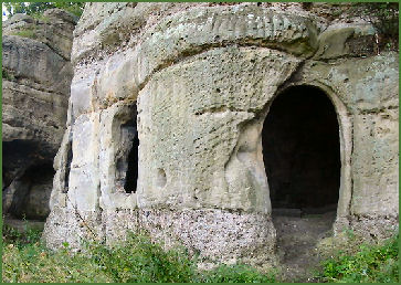
There is a public footpath at the bottom of the crag which is over 100 metres long and around 12 metres high. The rock is sansstone triassic conglomerate, which is a sediment with protruding beds of pebbles.
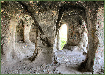
The outcrop was once part of the banks of the River Trent, the four interconnecting caves were originally formed by the action of flowing water on the rock. They are unusual in that they have since been artificially enlarged to form a crude dwelling place, complete with door and window holes. The course of the river has altered over the centuries and left the caves opening onto a quiet expanse of water, known as Black Pool.
The name Anchor Church derives from the term Anchorite, the caves are believed to have been the cell of an Anglo-Saxon Anchorite hermit, St Hardulph, who lived there in the sixth and seventh century. The nearby church at Breedon on the Hill is dedicated to St. Hardulph.
 In the medieval period, the caves were inhabited by a monk named Bernard, whom local legend states that during the reign of Henry II, one Hugo De Burdett was bribed into embarking on Crusade by Bernard at the instigation of the Baron of Boyvill who coveted his beautiful wife Johanne. Bernard the monk died there whilst doing penance for his involvement in the affair.
Written records of the caves are extant from 1658 when they are mentioned in Repton church records. In 1715, William Woolley wrote About half a mile eastward (from Foremark Hall), upon the side of the Trent, is a large cave dug out of a rock in the form of a chapel, called Anker church. It has been, as tradition informs us, an anchorites cell and it really is a most solitary, pleasant place. D P Davies, writing in 1811, also described the caves: Several excavations, or cells, which communicate with each other and give a probability to the tradition of its having been the residence of an anchorite; whence it has derived the name of Anchor Church.
Sir Francis Burdett of nearby Foremarke Hall enlarged the caves to the present size in the eighteenth century and used it for picnics by the river.
Directions
The best approach is from Ingleby, near the old Swarkestone Bridge across the Trent, along the public footpath which runs along the top of a steep bank before descending to the river and the caves.