The Peak District National Park
The Peak District National Park with its dramatic moorland and superb scenery, covers is an upland area of 555 square miles (1,440 km2) which lies mainly in northern Derbyshire, but also covers parts of Cheshire, Greater Manchester,and Staffordshire. It is conventionally split into the northern Dark Peak, where most of the moorland is found and whose geology is gritstone, and the southern White Peak, where most of the population are to be found and where the geology is mainly limestone-based. Peak derives from the Anglo-Saxon word 'Paec', meaning a knoll or hill and in 924 A.D. the area was referred to as 'Peacland'.
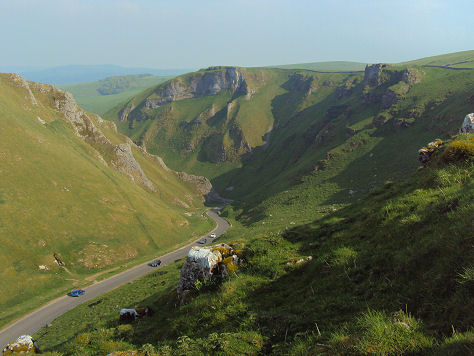
Winnat's Pass Peak District
The area was made into a national park in 1951, making it the first national park in Britain, it is also the largest. The Peak District offers a perfect setting for a range of outdoor activities outdoor activities from walking, climbing and cycling to abseiling and yachting.
The Peak District- what to see and where
The spa town of Buxton, the largest town in the Peak District was developed by the Dukes of Devonshire as a health resort in the eighteenth century, it boasts a fine Edwardian opera house with a theatre, the highly attractive Pavilion Gardens and a a museum and art gallery. Poole's Cavern or Poole's Hole as it is sometimes known, is a 2 million year old, natural limestone cave situated at Buxton Country Park on the edge of the town.
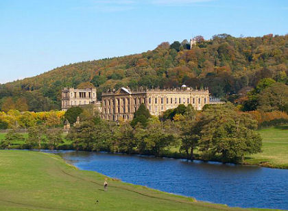
Historic buildings in the Peak District include Chatsworth House, seat of the Dukes of Devonshire and among Britain's finest stately homes, Hardwick Hall, built by powerful Elizabethan Bess of Hardwick and Lyme Park, situated in a spectacular moorland setting at Disley near Stockport on the edge of the national park. The house and surrounding estate are owned by the National Trust. The lavishly decorated Italianate style house has spectacular seventeen acre gardens, which include the Victorian Garden and Edwardian rose garden. The house is surrounded by 1,300 acres of medieval deer park. Haddon Hall near Bakewell, is an architectural gem. Dating back to the eleventh century, the hall has been described as "the most complete and most interesting house of [its] period", it is the finest example of a medieval manor house currently in existence in England.
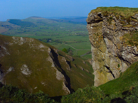
Left Mam Tor and right the picturesque village of Castleton overlooked by its Norman Castle
The charming village of Castleton, overshadowed by the Norman Peveril Castle, is a tourist magnet and has four show caves, the Peak Cavern, Blue John, Treak Cliff, and Speedwell Cavern, and is the centre of production of the unique semi-precious mineral, Blue John. Mentioned in the Domesday survey, Peveril Castle is one of Englands earliest Norman fortresses. The keep was built by King Henry II in 1176. Displays in the visitor centre tell the story of Peveril as the administrative focus of the Royal Forest of the Peak, a royal hunting preserve since the 11th century. The nearby Winnats Pass is the Peak Districts equivalent of Somersets Cheddar Gorge. A long collapsed limestone cave system, which is now a spectacular limestone gorge. It was formed by underwater sea currents cutting through a tropical reef some 350 million years ago.
The beautiful Goyt Valley on the Cheshire/Derbyshire border close to the town Macclesfield, contains some spectacular scenery, including high moorland, gritstone edges and the highly attractive Fernileee and Errwood reservoirs. To the south lies Goyt’s Moss and to the north the village of Fernilee. The western side of the valley is flanked by Shining Tor, which rises to a height of 1,833 ft and Cats Tor at 1,703 ft. Much of the land in the valley is readily open and accessible to walkers, with a network of paths and bridleways.
Macclesfield Forest is situated east of Macclesfield and west of the Goyt Valley. Macclesfield Forest was once the centre of a Royal Forest created by the Norman kings for the purpose of hunting game such as deer, wild boar and wolves. Controlled by the Norman Earls of Chester, it once encompassed all the area from Disley to the River Dane.
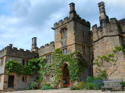
Left- Chatsworth House, seat of the Dukes of Devonshire and right-medieval Haddon Hall
The spectacular Upper Derwent Valley contains some of the most stunning scenery in the Peak District National Park. A deep valley surrounded by gritstone edges, it has three reservoirs, the Ladybower Reservoir, which is situated to the south of the valley, the centrally placed Derwent Reservoir and the Y shaped Howden Reservoir to the north. The three Derwent Valley Dams are famous for the Dambuster training runs during the Second World War. The dams were used as a practice environment fo low level flying techniques by the Lancaster bombers of the 617 Dam Busters Squadron in 1943 prior to their attack on the Ruhr dams.
Stunnng Dovedale is a highly popular Peak District beauty spot. The valley, which is owned by the National Trust, is cut by the River Dove and runs for just over 3 miles (5 km) between Milldale in the north and a wooded ravine near Thorpe Cloud in the south. The wooded ravine contains a set of stepping stones acrooss the river, a scene has graced many calendars, there are also two caves known as the Dove Holes.
The picture postcard village of Tissington, situated 3 miles north of Ashbourne, is rightly regarded as one of the most picturesque of English villages with its pale limestone cottages enriched in Autumn by Virginia Creeper and yellow lichens. The village forms part of the estate of Tissington Hall, owned by the aristocratic FitzHerbert family since 1465. The pretty village of Ashford-in-the-Water, arguably one of the most picturesque villages in the Peak District is situated on the banks of the River Wye around a mile and a half from the town of Bakewell. The village's name derives from an Anglo-Saxon source and means `ford by the ash trees'. The Sheepwash Bridge, originally a medieval packhorse bridge, now occupies the the site of the original ford.
The characterful village of Eyam, located 5 miles north of Bakewell is famous as the "plague village" that imposed isolation on itself when the plague broke out there in August of 1665, rather than let the infection spread to neighbouring areas. Today there many reminders of this great act of courage and selflessness in Eyam. The Coolstone, a stone in which money, usually soaked in vinegar, which was believed to kill the infection, was placed in exchange for food and medicine, can still be seen and many of the cottages carry a commemorative plaque, information boards at strategic points tell the story and give the details of the families who were so tragically affected.
Left- Gradbach in the White Peak and Lud's Church chasm, wreathed in myth and legend
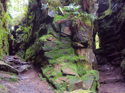
The Roaches, an iconic Peak District National Park landscape and a popular spot with climbers and walkers offer stunning panoramic views. Lud's Church, otherwise known as Ludchurch, is a deep, dank chasm in the White Peak, situated in an area known as the Black Forest, towards the southwest fringe of the Peak District National Park and a short walk from the small Cheshire hamlet of Gradbach. The impressive cleft was formed by a massive landslip of rock on the hillside forming a dog legged chasm over 100 yards in length and 20 yards high in places. Dripping grasses, mosses and ferns cling to the vertical sides of the atmospheric chasm, it remains cool even on warm days and is wreathed in myth and legend.
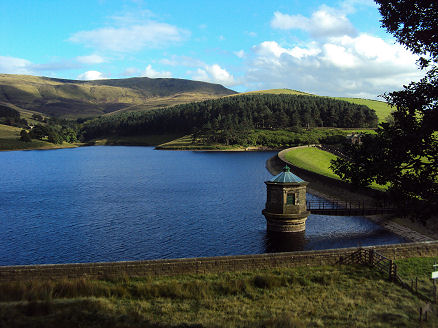
The windswept moorland plateau of Kinder Scout is one of the most well known mountains in England. There is no actual summit, the part of the moor known as Crowden Head rises to 636 metres (2,087 feet) is the highest point in the Peak District. Views from Kinder Scout on a clear day include the city of Manchester and the Greater Manchester conurbation, the Liverppol skyline as well as Winter Hill near Bolton, and the mountains of Snowdonia in North Wales. The dramatic Kinder Downfall on Kinder Scout is the highest waterfall in the Peak District National Park, with a 30 metre drop. The plateau was the subject of a planned mass trespass in April 1932 which Roy Hattersley has described as "the most successful direct action in British history", seen as a working class struggle for the right of walkers to roam versus the rights of the wealthy to have exclusive use of moorlands for grouse shooting. Panoramic Kinder Reservoir is situated two miles upstream of the picturesque village of Hayfield at the head of the Kinder Valley.
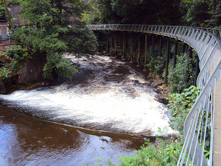
Kinder Reservoir and the Millenium Walkway at the Torrs in New Mills
Another Peak District beauty spot is the famous and much photographed viewpoint of Monsal Head, in the White Peak, some 500 feet/150m above the winding valley of the River Wye. A tributary of the main Wye (river) valley and a superb example of a typical Peak District dry limestone dale, Deepdale contains a plantlife reserve owned by the Derbyshire Wildlife Trust and has recently been awarded SSSI status (Site of Special Scientific Interest).
Eldon Hole is one of the seven wonders of the Peak. It is the deepest local pothole; an alarming chasm in the side of Eldon Hill to the north of the village of Peak Forest.
Some of the area's highest peaks are Kinder Scout at 636m (2,087 feet), Bleaklow at 633m (2,077 feet), Grindslow Knoll 601m (1,972 feet) and Black Hill which rises to 582m (1,909 feet).