Bradwell
OS Grid ref:-
 The large, attractive village of Bradwell lies just to the south of the Hope Valley, in the Peak District National Park.
Bradwell is mentioned in the Domesday Book, where it is referred to as Bradewelle, it then belonged to William Peveril, thought to be the illegitimate son of William the Conqueror.
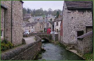
 Bradwell Brook flows through the village's main street, most of the cottages in the village date from the eighteenth and nineteenth centuries. Bradwells famous Dairy Ice Cream can still be purchased from the small cottage shop where Hannah Bradwell invented the recipe over 100 years ago. There are a number of inns in the village including the White Hart, which dates back to 1676.
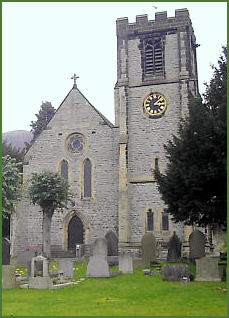
The village church of St Barnabas (pictured right) dates to 1868, the pulpit and altar rails boast early eighteenth century carved panels. Opposite the church is a small cottage in Water Lane once occupied by local benefactor Samuel Fox once lived. He was born in 1815 and is famous for inventing the paragon umbrella frame.
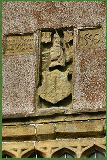
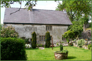
The oldest building in the village is Hazlebadge Hall, (pictured below right) which dates to 1549, and stands at the top of Bradwell Dale on the road to Tideswell. The crests of the Swynnerton and Vernon families are proudly displayed on its gable end (pictured below left). The building which survives today is but one wing of a much larger hall, owned by the Vernon family, local landowners who inhabited the hall for some three hundred years.
 The original Hazlebadge Hall was part of the Peveril Estate, owned by the descendants of William Peverel, who built Peveril Castle at nearby Castleton. In 1154 it was inherited by the Strelley family and from them passed to the Vernons in 1421. Sir Richard Vernon, once High Steward of the Royal Forest of the Peak, held courts at Hazlebadge Hall and became infamous for handing out severe penalties. Margaret Vernon was the last of the Vernon family and is said that she lost her senses after witnessing the marriage of her lover to a rival at nearby Hope Church. Her ghost is reputed to haunt the hall The single surviving wing of the hall now forms part of a large farm complex.
Bagshawe Cavern, otherwise known as the Crystallized Cavern, was discovered in 1806 by local lead miners whilst excavating the Mulespinner Mine. The Cavern once operated as a Show Cave,but is now only used for educational trips and for potholing and is open to the public by appointment only.
 Edden Tree or Edwins Tree at Bradwell is said to be named after an Anglo-Saxon king, who legend states was hanged there after a great Dark Age battle fought on nearby Win Hill and Lose Hill, said to have been fought in 626 AD. The army of Prince Cwichelm and his father, Cynegils, King of Wessex, stationed on nearby Lose Hill and probably aided by Penda, King of Mercia, advanced on the Northumbrians, who were based on Win Hill. The battle was long and fierce, any by the end the river Noe, which flows between the two hills, is reported to have ‘ran red with blood’. Despite having superior numbers, Cynegils forces were defeated by the Northumbrians who built a wall and rolled boulders down upon them. Although there is no record of this battle occuring in any contemporary Anglo-Saxon source, archaeological finds associated with the battle include a large quantity of bones and old weapons which were unearthed near Gore Lane.
A few Roman remains have been found in Bradwell, associated with the nearby Navio fort at Brough-on-Noe, these include Roman coin hoards and a Roman bath. The New Bath Inn stands by the site of a medicinal spring, which was originally Roman but was revived in the Georgian era.
On the moors of Bradwells Northern edge, lay a large Dark Age mound with a ditch runs from Bradwell Edge to Micklow Hill. Known as Grey Ditch, it is thought to have been built as a defensive territorial division between the Anglo-Saxon tribes of Mercia and Northumbria and was constructed between the fifth and sixth centuries. Excavations have revealed the bank was about 8 metres wide at its base, and 1.2 metres high, and it has been suggested that Bradwell or Broad Wall may have derived its name from this ditch.
Bradwell Edge is popular with handgliders and paragliders and offers stunning views which cover the Ladybower Dam and Win Hill to the north, with Losehill and Kinder Scout visible beyond.
Nearby places of interest
Treak Cliff Cavern is a show cave of international fame and geological importance, located on the Old Mam Tor road near Castleton.
Winnats Pass a dramatic ravine, lying just to the west of Castleton.
Animal Farm is a conservation farm park based just outside Castleton. The Farm, which makes an interesting and enjoyable place to visit, provides a home for British farm animals which face extinction and a wonderful opportunity for you to meet them.
Eldon Hole is deepest pothole in Derbyshire and is situated on the southern side of Eldon Hill, which lies four kilometres to the southwest of the village of Castleton.
The Chestnut Centre Conservation and Wildlife Park is set in 50 acres of landscaped grounds and is home, not only to a unique collection of birds and animals, but to many wild birds and mammals. The centre contains one of Europe's largest gathering of otters, 16 species of owls and other indigenous wildlife all in their natural surroundings including, buzzards, pine martens, polecats, red foxes, Scottish wildcats and deer.