Glossop
OS Grid ref:- SK0393
 The market town of Glossop is situated around 15 miles (24 km) to the east of Manchester, it lies near Derbyshire's county borders with Cheshire, Greater Manchester, and Yorkshire and is often described as "the gateway to the Peak District National Park".
An ancient settlement, Glossop is mentioned in the Domesday Book of 1086, where it is recorded as being owned by William Peverel, known as 'Peverel of the Peak', who owned extensive estates in Derbyshire and Nottingham and is thought to be the illegitimate son of William the Conqueror.
The name Glossop is considered to be of Anglo-Saxon origin and possibly derives from Glott's Hop meaning Glott's Valley.
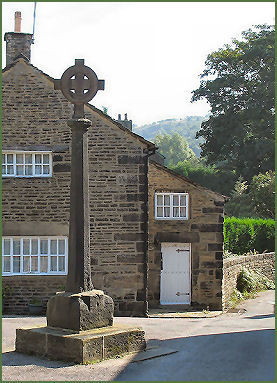
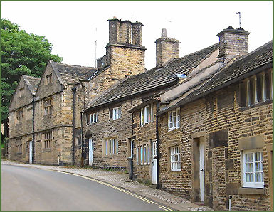 Glossop now covers the villages that used to be known as Glossopdale, it was once a centre of wool processing, but rapidly expanded during the Industrial Revolution. The original village of Glossop is now known as Old Glossop (pictured right). Old Glossop retains much of its character and has some interesting buildings including old cottages dating from the seventeenth and eighteenth century cottages and a handsome church. There is a history trail around the village, the footpath known as "Doctors Gate", leads up the Snake Pass and the Pennine Way.
During the middle ages, from 1157 to the late fifteenth century, Glossop and its surrounding lands belonged to Basingwerk Abbey in North Wales. The monks set up crosses at several locations around Glossop to mark the boundaries of their property. One of these crosses still stands at Old Glossop. Now known as the Glossop Old Cross, it probably dates from the sixteenth century when the area was leased from Basingwerk by the Talbot Family. There was an earlier one from the first market charter in 1290.
Norfolk Square at the centre of the town contains a number of fine buildings including the Town Hall and the Market Hall, designed in Italianate style by Sheffield architects Weightman and Hadfield.
Wren's Nest Mills situated on High Street West dates from around 180010. The building which survives to the present day is a small part of the original complex, which in its heyday employed 1,400 workers operating 123,000 spindles and 2541 looms. The mill closed in 1955.
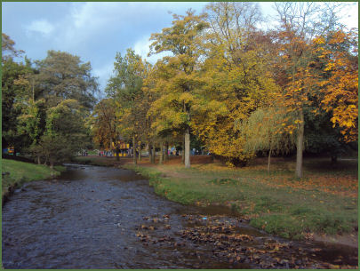
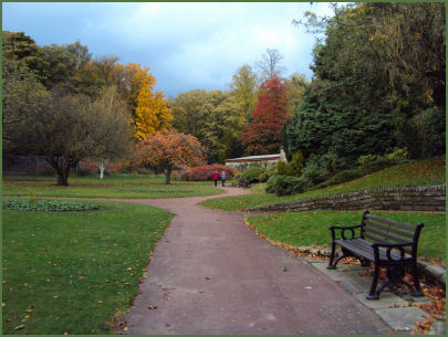
Manor Park near to the centre of the town, is set in 60 acres of gardens, woodlands and lakes and has been given the coveted Green Flag award. Manor Park commands spectacular views of the surrounding countryside. The park provides a range of facilities including crazy golf, model railway, a sensory garden, rose garden, bowling greens, tennis and basketball courts and a cafe.
Autumnal views of Manor Park
Picturesque Howard Park set within its own conservation area, also holds the Green Flag award, was described by the Award organisation as "a good example of visionary layout from the Victorian era retaining many original features" the park has formal landscaping, including a lake, floral displays, specimen trees, herbaceous border, shrubberies, a highly attractive wildflower meadow and swimming baths (which were donated by local rich mill owners in the late nineteenth century). Harehills Park, has a riverside footpath and mature trees, it was donated to the town by the 2nd Lord Howard of Glossop as a World War I memorial.
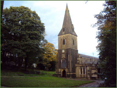
The Parish Church of All Saints occupies the site of a former medieval church. Lord Bernard Edward Howard, 12th Duke of Norfolk rebuilt the old parish church in 1831. The nave was remodelled 1913 by Charles Hadfield and the chancel added in 1924 by M Hadfield.
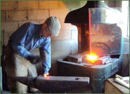
The Glossop Forge, a traditional country blacksmith, situated near the Old Cross in Old Glossop is open to browsers and observers on Saturdays and Bank Holidays.
All Saints church and inside the Glossop Forge
The Longdendale valley, to the north of the town, boasts five reservoirs and the Longdendale Trail, a cycle and walking trail, part of the Trans-Pennine Trail long distance footpath.
Melandra Castle, also possibly known as Ardotalia, is situated 2 miles to the west of Glossop (OS Grid ref:- SK00919505) and was a garrison fort built by the Romans to protect the route over the Pennines between the Legionary fortresses at Lincoln and Chester.
There are superb views up the valley to the Derbyshire High Peaks. The fort was excavated by Manchester University revealing fort walls, a shrine and the fort headquarters and is a scheduled monument in the care of English Heritage. The site has been landscaped to provide parking and picnic areas.
Nearby places of interest
Etherow Country Park, consists of approximately 92 hectares at the heart of the Etherow-Goyt Valley and occupies the site of an old cotton mill. The park offers a variety of leisure pursuits.
Kinder Scout, a moorland plateau, rising to 636 metres (2,087 ft) which is highest point in the Peak District.
Lyme Park is situated in a spectacular moorland setting at Disley near Stockport on the edge of the Peak District National Park. The house and surrounding estate are owned by the National Trust. The lavishly decorated Italianate house has spectacular seventeen acre gardens, which include the Victorian Garden and Edwardian rose garden.
Mellor Iron Age Fort Iron Age settlement discovered in the 1990's, occupied from the Bronze Age to the Romano-British period, featuring a reconstructed Iron Age roundhouse.
Dunge Valley Gardens are situated just to the west of Windgather Rocks and are well worth a visit, especially in April and May when the rhododendron's are in bloom.