The Goyt Way
The Goyt Way is a 10 mile footpath, linking the Manchester conurbation with the Goyt Valley and the Peak District National Park along the Peak Forest Canal and the River Goyt.
The Millenium Walkway, the Torrs
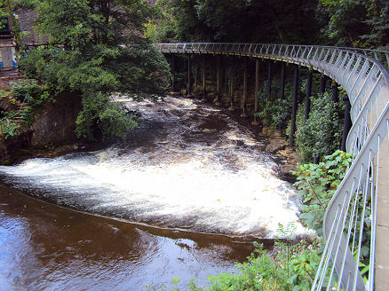
Commencing at the Canal Basin in the town of Whaley Bridge (OS grid ref SK012814), the route commences along the towpath of the Peak Forest Canal, to join the River Goyt and pass through New Mills, The dramatic Torrs at New Mills, 'the Park under the Town' is a 30 metre deep sandstone gorge through which the Rivers Goyt and Sett flow, The winding gorge was cut by glacial melt water. The stunning Torrs Millennium Walkway an 175-yard aerial walkway in the gorge, was built at a cost of £525,000 and spans the otherwise inaccessible cliff wall which rises steeply above the River Goyt. The shining steel walkway takes the visitor over the largest weir on the Goyt.
The Peak Forest Canal at Marple
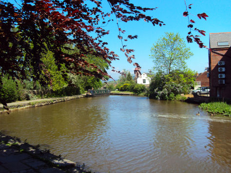
The route passes the village of Strines before entering Marple, which stands on the site of a major intersection of the Upper and Lower Peak Forest Canals with the Macclesfield Canal and has an important British Waterways Depot Yard on the junction, with a nearby flight of 16 picturesque locks leading down to Portland Basin in Ashton-under-Lyne.
The way eventually ends in Etherow Country Park (OS grid ref SJ966909) at Compstall in Stockport. the Park consists of approximately 92 hectares at the heart of the Etherow-Goyt Valley and was one of the first country parks in England.
The Goyt Way has many car parks and points of access along its route, providing the opportunity to either walk all of the route, or just sections of it.
Ordnance Survey Explorer Maps 268, 277.