High Legh
OS Grid ref:- SJ700840
The village of High Legh is situated around six miles north west of Knutsford.
The village was recorded in the Domesday Survey as being owned by two Saxons theins, Wulfgeat, and Dob. The boundary between Mere and High Legh is still known as Dobb Lane and once formed the medieval boundary between the two parishes.
High Legh has evidence of Roman occupation, a moated site was found at the village, by the Roman road which connected Wilderspool and Latchford to Watling Street, it contained Samian pottery from Cirencester, a Roman cloak clasp and a knife. Saxon remains have also been uncovered in a ploughed-out barrow off Peacock Lane belonging to a high ranking Saxon and aerial photographs revealed a series of round houses and dwellings in Renshards Place.
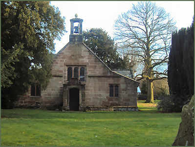
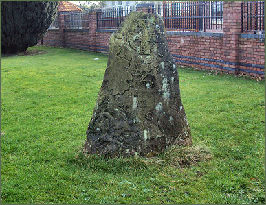
St Mary's Chapel High Legh and the Millenium Stone in the Churchyard
The village was home to two ancient landed gentry families, the Leigh family of West Hall and Legh of East Hall. Both halls have now been demolished, but both families are still represented today, the head of the West Hall family being Edward Leigh MP and that of the East Hall family headed by Richard, 6th Baron Grey of Codnor. The Leghs of East Hall descended from Edward de Lega, who lived during the reign of William II. The elder branch of the family became extinct in the male line around the time of the reign of Edward IV (1461-1483). During the reign of King Henry VIII, Thomas Legh of Northwood, who was a descendant of a younger son of John Legh, who lived about the time of Edward II's reign (1307-1327), pursued his claim to the inheritance and after a long legal battle succeeded to the East Hall estate. The East Hall was rebuilt in Elizabethan times and again for for Henry Cornwall Legh between 1781 and 1784. The building was demolished in 1963. The Leighs of West Hall arrived in High Legh about 70 years after the Leghs of East Hall. They descended from Richard Lymme who in the late thirteenth century married Agnes the daughter and sole heiress of Richard de Legh. West Hall, which is now sadly demolished was a timber framed building, not dissimilar to Little Moreton Hall in its original appearance.
There were several marriages which bonded the great Cheshire estates. A relatively minor branch of the powerful Egerton family, which owned vast tracts of land in Cheshire, Lancashire and Staffordshire, lived at Tatton Park and owned a quarter of High Legh parish. Their family married into the Leighs of West Hall and from the late seventeenth century, became known as the Egerton-Leighs. The Leghs of East Hall also extended their family name in the 1700s with the marriage of George Legh to Anna-Maria Cornwall of Burford, Shropshire. These landed families swapped and consolidated their estates throughout the eighteenth and nineteenth centuries until the Egerton Leighs sold their High Legh estate to the Cornwall-Leghs just before World War I. When Maurice, the last Lord Egerton of Tatton, sold off the remaining farms and land in High Legh in the 1930s.
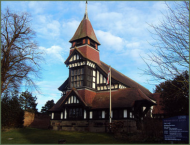
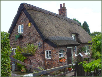
St John's Church and thatched cottage at Moss Lane
The village has an early Methodist chapel with Wesleyan connections, situated in Northwood Lane. The Chapel was founded by the Okell family of High Legh, who married into the Egerton Leigh (West Hall) family.
St Mary's Chapel, on Pheasant Walk, was formerly the domestic chapel of the Cornwall-Legh family of High Legh Hall (or East Hall) and was built around 1581. It may have replaced a chapel mentioned in the Domesday Book. The ceiling boasts nineteenth century pargeting with Tudor roses, fleurs de lys and stars. The pews date to 1858 are by Butterfield and the wainscotting and screens of 1884 by are by J. Oldrid Scottand. To mark the 2000 Millennium a carved stone was erected in the grounds of the chapel
The Parish Church of St John, an attractive black and white building, was formerly the domestic chapel of the West Hall (Egerton Leigh family). It was built in about 1814, with an Ionic front, to a design by Thomas Harrison. The chapel was destroyed by a fire in 1891 and the remaining stone walls were used as a base for a new church designed by Edmund Kirby in 1893.
Nearby places of interest
Tabley Hall, situated at Nether Tabley around 2 miles from Knutsford, is an elegant, brick built, Grade I listed building in the Palladian style, the only one of its type in the North West.
Gauntlet Birds of Prey Eagle and Vulture Park, which is situated at Knutsford is Cheshire's largest Falconry Centre. The centre hosts the biggest collection of birds of prey in the North West, and features a comprehensive collection of eagles, vultures, falcons, kites, hawks and owls. Gauntlet offers a wide range of services including falconry courses, flying displays for shows and events, school visits, children's parties and photography workshops.