Warton Crag
OS Grid ref:- SD492727
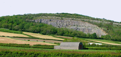 The limestone hill of Warton Crag in north west Lancashire lies to the north west of Warton village, 1.5km to the north of Carnforth.
Rising to 163 metres (535 feet) the crag is the highest point in the Arnside and Silverdale Area of Outstanding Natural Beauty (AONB).
The name is derived from the Anglo-Saxon word 'weard' meaning watch or look-out and 'tun' farmstead and from the Celtic word 'crug' meaning a hill or mound.
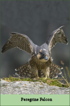
Warton Crag consists of is a mixture of limestone grassland with scrub and woodland. Two areas of the crag are Nature Reserves, namely Warton Crag and Warton Crag Quarry. The former quarry on the west side of the hill is a regular breeding site for peregrine falcons and is protected by a Falcon Watch team of volunteers. These amazing birds are masters of flight, stunning their prey, such as pigeons. at speeds of up to 180mph. Other birds which inhabit Warton Crag include Blackcap, Bullfinch, Marsh Tit, Garden Warbler, Raven, Green Woodpecker, Kestrel and Woodcock, which frequent the wooded bracken glades.
 A variety of plants are to be found on Warton Crag, including horseshoe vetch near its northern limit, spindle tree and many ferns. Other plants found therer are wood anemone, bluebells, cowslip. early purple orchid, bird's foot trefoil and marjoram, while there are stunning displays of spindle berries in the Autumn.
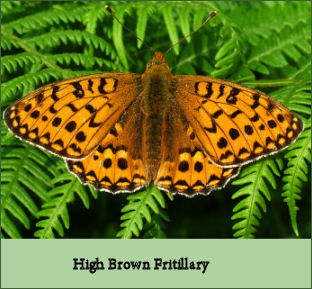 The site is rich in butterflies and moths, including the endangered and highly attractive butterfly, the High Brown Fritillary and several other varieties of fritillary. Pearl-bordered Fritillary are often sighted there in early May, Small
Pearl-bordered Fritillary in late May and June and Dark Green Fritillary from early July. High Brown Fritillary may be seen on the crag in mid July, as well as dozens of other butterfly species.
The site is rich in butterflies and moths, including the endangered and highly attractive butterfly, the High Brown Fritillary and several other varieties of fritillary. Pearl-bordered Fritillary are often sighted there in early May, Small
Pearl-bordered Fritillary in late May and June and Dark Green Fritillary from early July. High Brown Fritillary may be seen on the crag in mid July, as well as dozens of other butterfly species.
Views from the summit of the crag take in the estuary of the River Keer, the vast tidal expanse of Morecambe Bay to the south and west, the Bowland Fells to the south-east and Ingleborough in the Yorkshire Dale National Park to the east.
There is evidence to suggest there has been human occupation on Warton Crag stretches back to prehistoric times. Objects from Neolithic and Romano-British times have been discovered there, and the southern end of the summit is thought to be the site of a hillfort of the Ancient Celtic Brigantes tribe who once inhabited much of Northern England. The surviving visible defences of the fort appear as three concentric arcs forming the northern and eastern sides of the enclosure, a south-eastern gap in the inner bank may have been an original entrance to the inner area of the fort. The hillfort may date back to the 1st century and the time of King Venutius of the Brigantes.