The Roman Bath House and Wery Wall Remains
OS Grid ref:-
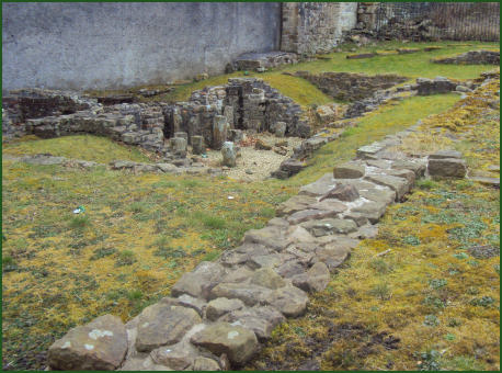
 The Wery Wall, a surviving fragment of the Roman fort at Lancaster, is situated on the east slope of Castle Hill adjacent to the rear of Mitre House.
Standing on a steep bank which runs north to south, the remains measures 4 metres by 3 metres and stand at 3 metres high. It was erected some time in the fourth century, probably around 330 AD.Only the rubble core of the wall remains, the facing stones have not survived.
The first fort on the site may date to as early as 80 AD, but this was rebuilt on at least 6 occasions over the ensuing centuries until the last fort was abandoned in the early 5th century. The final rebuilding took place in 367 AD when the fort was contracted in size.
Old documents suggest that there was considerably more of the wall existed up to the eighteenth century, but it is now impossible to trace its full course. The remains represent a section of a bastion of the last Roman fort on the site, which probably dates to the fourth century.
 The visible earthwork rampart in Vicarage Field follows the line of the earlier Roman defences but is not itself Roman. In the west, its highest point, it overlies the Roman ditches. The rampart consists of a thick mound of earth up to 4 feet deep. Medieval green-glazed pottery found at the site suggests that this rampart is medieval. The earthwork defences may be connected with the Lancaster Priory or Castle, which both stand on the hill and occupy a section of what was once the Roman fort.
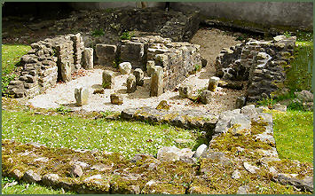
Adjacent to the Wery Wall are the remains of a small bathhouse. The bath house formed one end of a large courtyard house, probably the home of a Roman official. It was demolished in about 340AD to make way for a new and massive stone fort. The remains were preserved by excavations in 1973 prior to re-development of the site.
The bathhouse was once decorated with painted plaster and was subject to one or two redecorations, the last of which occured no later than 330 A.D. Another Bathouse, generally referred to as 'Bathhouse II' was discovered in the vicinity of Mitre House
. There have also been many Roman finds in Church Street. Four mortaria, made by the potter Decanus, were found at number 80, suggesting it was once a potter's shop. Excavations at number 65 discovered animal bones and cooked meat, probably indicating the presence of another business. The remains of a timber building, destroyed by fire, and grain, at number 41, may imply a grain store or bakery. Many of the artefacts from the Roman occupation of Lancaster are now displayed at the city museum.
Directions
Exit the M6 at Junction 34 and follow signs for Lancaster. Join the one way system (Caton Road) and pass a small retail park on the left on the approach to traffic lights. Turn left following signs for Lancaster City Centre.